

Note
Go to the end to download the full example code or to run this example in your browser via Binder.
Meshes from YAML#
This example shows how to generate OGS-ready VTU meshes directly from a YAML
geometry description using from_yaml().
The YAML schema de…ot.definitions..ogstoolsines the mesh in terms of fdefinitionsop-lepathseys:
parameters - scalar values and expressions that can be reused in the geometry
points - coordinates and local mesh sizes
lines - connections between points (straight or circular arcs)
surfaces - closed loops of lines/arcs, optionally with holes
groups - physical groups (domains, boundaries, subregions)
Together these building blocks allow you to describe arbitrary 2D geometries, assign regions and boundaries, and directly obtain a conforming triangular mesh.
Internally, Gmsh is still used to build the geometry and generate a .msh file,
but from_yaml() converts the result
immediately into a Meshes object with VTU
submeshes (domain, boundaries, and groups) that can be used directly in OGS.
import ogstools as ot
from ogstools.definitions import EXAMPLES_DIR
Example YAML geometry#
An example geometry is provided in ogstools/examples/meshlib/meshes_from_yaml/example_hlw.yml.
yaml_file = EXAMPLES_DIR / "meshlib/meshes_from_yaml/example_hlw.yml"
yaml_content = yaml_file.read_text(encoding="utf-8")
print(yaml_content)
# -----------------------------------------------------------------------------
# Example geometry definition for gmsh-wrapper YAML
# -----------------------------------------------------------------------------
# This YAML file demonstrates how to define a 2D tunnel cross-section
# with several subdomains (host rock, excavation damage zone, support,
# floor, canister, filling). The syntax is essentially a wrapper around
# the gmsh Python API, with identical keywords (e.g. 'start', 'end',
# 'center' for arcs).
#
# All identifiers (names of points, lines, surfaces, groups) are written
# in quotation marks ("..."). This is recommended to clearly separate
# them from keywords like 'start' or 'end'.
# -----------------------------------------------------------------------------

parameters:
  # --- User-defined parameters (geometry input) -----------------------------
  "domain_width": 40.0              # width of the rectangular outer domain
  "domain_height": 60.0            # height of the rectangular outer domain
  "tunnel_radius": 6.0              # tunnel radius
  "support_thickness": 1.8          # thickness of support layer
  "edz_thickness": 10               # thickness of excavation damaged zone
  "floor_width": 10.0               # tunnel floor width
  "canister_height": 8.0           # canister height
  "canister_width": 6.5            # canister width

  # --- Derived parameters ---------------------------------------------------
  # Mathematical expressions can be used here. They are evaluated with
  # 'eval' (actually via the Python package 'simpleeval'), so functions
  # like sqrt() are supported.
  "center_x": "domain_width/2"      # domain center (x)
  "center_y": "domain_height/2"     # domain center (y)

  # floor_level is computed from tunnel radius and floor width
  "floor_level": "center_y - sqrt(tunnel_radius**2 - (floor_width/2)**2)"

  # characteristic lengths control mesh element sizes in different regions
  "domain_size": "(domain_width + domain_height)/2"
  "char_length_domain": "domain_size/10"
  "char_length_edz": "edz_thickness/5"
  "char_length_support": "support_thickness/5"
  "canister_size": "(canister_height+canister_width)/2"
  "char_length_canister": "canister_size/20"

# -----------------------------------------------------------------------------
# Point definitions
# Each point has coordinates (x,y) and a target mesh element size
# ('char_length'). Coordinates can be numeric or expressions.
# -----------------------------------------------------------------------------
points:
  # Outer domain corners
  "d_bottom_left":  { coords: [0.0, 0.0], char_length: "char_length_domain" }
  "d_bottom_right": { coords: ["domain_width", 0.0], char_length: "char_length_domain" }
  "d_top_right":    { coords: ["domain_width", "domain_height"], char_length: "char_length_domain" }
  "d_top_left":     { coords: [0.0, "domain_height"], char_length: "char_length_domain" }

  # Reference circle center (used for arcs)
  "r0": { coords: ["center_x", "center_y"], char_length: 0.3 }

  # Tunnel boundaries (top and bottom points of tunnel arc)
  "t_top":    { coords: ["center_x", "center_y + tunnel_radius"], char_length: "char_length_support" }
  "t_bottom": { coords: ["center_x", "center_y - tunnel_radius"], char_length: "char_length_support" }

  # Support boundaries
  "s_top":    { coords: ["center_x", "center_y + tunnel_radius + support_thickness"], char_length: "char_length_support" }
  "s_bottom": { coords: ["center_x", "center_y - tunnel_radius - support_thickness"], char_length: "char_length_support" }

  # EDZ boundaries
  "e_top":    { coords: ["center_x", "center_y + tunnel_radius + support_thickness + edz_thickness"], char_length: "char_length_edz" }
  "e_bottom": { coords: ["center_x", "center_y - tunnel_radius - support_thickness - edz_thickness"], char_length: "char_length_edz" }

  # Tunnel floor edges
  "f_left":  { coords: ["center_x - floor_width/2", "floor_level"], char_length: 0.3 }
  "f_right": { coords: ["center_x + floor_width/2", "floor_level"], char_length: 0.3 }

  # Canister corners
  "c_bottom_left":  { coords: ["center_x - canister_width/2", "floor_level"], char_length: "char_length_canister" }
  "c_bottom_right": { coords: ["center_x + canister_width/2", "floor_level"], char_length: "char_length_canister" }
  "c_top_right":    { coords: ["center_x + canister_width/2", "floor_level + canister_height"], char_length: "char_length_canister" }
  "c_top_left":     { coords: ["center_x - canister_width/2", "floor_level + canister_height"], char_length: "char_length_canister" }

# -----------------------------------------------------------------------------
# Line and arc definitions
# - A straight line requires 'start' and 'end'
# - A circular arc requires 'start', 'end', and 'center'
# - Elliptical arcs are not supported yet, they will follow in a future release
# -----------------------------------------------------------------------------
lines:
  # Outer domain rectangle
  "domain_bottom": { start: "d_bottom_left", end: "d_bottom_right" }
  "domain_left":   { start: "d_bottom_left", end: "d_top_left" }
  "domain_top":    { start: "d_bottom_right", end: "d_top_right" }
  "domain_right":  { start: "d_top_right", end: "d_top_left" }

  # Tunnel (half-circle, split into left, bottom, right arcs)
  "tunnel_arc_left":   { start: "t_top", end: "f_left", center: "r0" }
  "tunnel_arc_bottom": { start: "f_left", end: "f_right", center: "r0" }
  "tunnel_arc_right":  { start: "f_right", end: "t_top", center: "r0" }

  # EDZ arcs
  "edz_arc_left":  { start: "e_top", end: "e_bottom", center: "r0" }
  "edz_arc_right": { start: "e_bottom", end: "e_top", center: "r0" }

  # Support arcs
  "support_arc_left":  { start: "s_top", end: "s_bottom", center: "r0" }
  "support_arc_right": { start: "s_bottom", end: "s_top", center: "r0" }

  # Floor and canister
  "floor_line_1": { start: "f_left", end: "c_bottom_left" }
  "floor_line_2": { start: "c_bottom_left", end: "c_bottom_right" }
  "floor_line_3": { start: "c_bottom_right", end: "f_right" }

  "canister_bottom": { start: "c_bottom_left", end: "c_bottom_right" }
  "canister_right":  { start: "c_bottom_right", end: "c_top_right" }
  "canister_top":    { start: "c_top_right", end: "c_top_left" }
  "canister_left":   { start: "c_top_left", end: "c_bottom_left" }

# -----------------------------------------------------------------------------
# Surface definitions
# Each surface is defined by one or more "loops".
#
# - A loop is a closed contour made of line/arc segments.
# - Segments must connect without gaps; their orientations must be consistent.
# - A leading minus ("-segment") reverses the orientation of that segment.
# - All segments in a loop must share the same orientation (either CCW or CW).
# - CCW loops define positive surfaces.
# - CW loops define holes (subtracted regions from the parent surface).
# -----------------------------------------------------------------------------
surfaces:
  "host_rock":
    loops:
      - [ "domain_bottom", "domain_right", "domain_top", "-domain_left" ]
        # Outer domain loop (counter-clockwise). 'domain_left' is reversed so
        # that all lines follow a consistent CCW orientation.
      - [ "-edz_arc_right", "-edz_arc_left" ]
        # Inner loop (clockwise). Because this loop is CW, gmsh interprets it
        # as a hole → the EDZ region is subtracted from the host rock.

  "edz":
    loops:
      - [ "edz_arc_left", "edz_arc_right" ]
        # Outer EDZ loop (CCW, positive surface).
      - [ "-support_arc_right", "-support_arc_left" ]
        # Inner support loop (CW, hole). Support is cut out from EDZ.

  "support":
    loops:
      - [ "support_arc_left", "support_arc_right" ]
        # Outer support loop (CCW).
      - [ "-tunnel_arc_right", "-tunnel_arc_left", "-tunnel_arc_bottom", ]
        # Inner tunnel loop (CW). Tunnel is cut out from support.

  "floor":
    loops:
      - [ "floor_line_1", "floor_line_2", "floor_line_3", "-tunnel_arc_bottom" ]
        # Rectangular floor slab. The bottom arc is reversed to ensure CCW.

  "canister":
    loops:
      - [ "canister_bottom", "canister_right", "canister_top", "canister_left" ]
        # Simple rectangular canister (CCW).

  "filling":
    loops:
      - [ "floor_line_1", "-canister_left", "-canister_top", "-canister_right",
          "floor_line_3", "tunnel_arc_right", "tunnel_arc_left" ]
        # Complex filling region: outer floor + tunnel arcs, with the canister
        # subtracted (CW inner loop).

# -----------------------------------------------------------------------------
# Groups
# Groups are collections of geometric entities (points, lines, or surfaces)
# grouped under a common name. They define physical groups in gmsh.
# The 'dim' field specifies the geometric dimension:
#   dim=0: points, dim=1: lines, dim=2: surfaces.
# -----------------------------------------------------------------------------
groups:
  "Hostrock":   { dim: 2, entities: ["host_rock"] }
  "EDZ":        { dim: 2, entities: ["edz"] }
  "Support":    { dim: 2, entities: ["support"] }
  "Floor":      { dim: 2, entities: ["floor"] }
  "Canister":  { dim: 2, entities: ["canister"] }
  "Filling":    { dim: 2, entities: ["filling"] }

  # Boundary groups, e.g. for BCs etc.
  "Domain_Left":   { dim: 1, entities: ["domain_left"] }
  "Domain_Top":    { dim: 1, entities: ["domain_top"] }
  "Domain_Right":  { dim: 1, entities: ["domain_right"] }
  "Domain_Bottom": { dim: 1, entities: ["domain_bottom"] }

  # 0-dimensional entities, for e.g. observation points
  "Observation_Point": { dim: 0, entities: ["t_top"] }
Mesh generation#
# Using :meth:`~ogstools.Meshes.from_yaml` we create
# a :class:`~ogstools.Meshes` container directly from
# the YAML file.

# Internally, a Gmsh `.msh` file is generated, but it is automatically
# converted into VTU meshes. The returned object already provides
# access to all named meshes (domain, boundaries, groups) and can be
# queried or plotted without further conversion.
meshes = ot.Meshes.from_yaml(yaml_file)
print(*[f"{name}: {mesh.n_cells=}" for name, mesh in meshes.items()], sep="\n")
Info: Mesh written to /tmp/ogstools_root/meshes_from_yaml4745723a4eb84603a9f64794b54d7daa/mesh.msh

domain: mesh.n_cells=6500
Observation_Point: mesh.n_cells=1
Domain_Left: mesh.n_cells=12
Domain_Top: mesh.n_cells=12
Domain_Right: mesh.n_cells=8
Domain_Bottom: mesh.n_cells=8
Hostrock: mesh.n_cells=352
EDZ: mesh.n_cells=2110
Support: mesh.n_cells=1694
Floor: mesh.n_cells=450
Canister: mesh.n_cells=976
Filling: mesh.n_cells=918
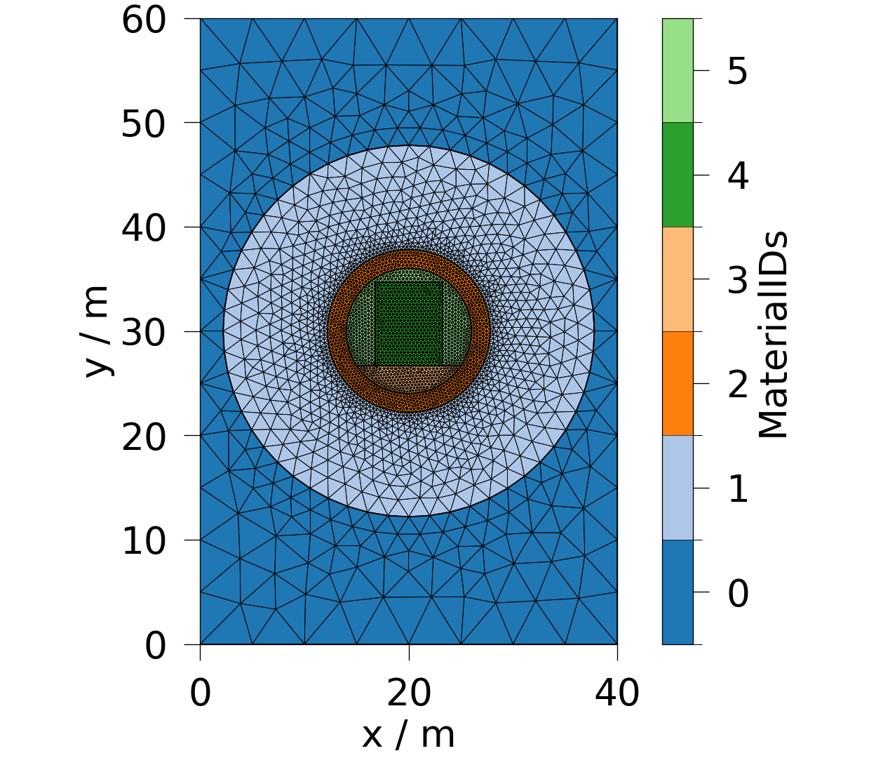
Plot the domain mesh#
Here we plot the domain mesh with material IDs shown.
fig = ot.plot.contourf(meshes.domain, ot.variables.material_id, show_edges=True)
Saving meshes
meshes.save()
[PosixPath('/tmp/ogstools_root/Meshes/20260601_131748_087675/domain.vtu'), PosixPath('/tmp/ogstools_root/Meshes/20260601_131748_087675/Observation_Point.vtu'), PosixPath('/tmp/ogstools_root/Meshes/20260601_131748_087675/Domain_Left.vtu'), PosixPath('/tmp/ogstools_root/Meshes/20260601_131748_087675/Domain_Top.vtu'), PosixPath('/tmp/ogstools_root/Meshes/20260601_131748_087675/Domain_Right.vtu'), PosixPath('/tmp/ogstools_root/Meshes/20260601_131748_087675/Domain_Bottom.vtu'), PosixPath('/tmp/ogstools_root/Meshes/20260601_131748_087675/Hostrock.vtu'), PosixPath('/tmp/ogstools_root/Meshes/20260601_131748_087675/EDZ.vtu'), PosixPath('/tmp/ogstools_root/Meshes/20260601_131748_087675/Support.vtu'), PosixPath('/tmp/ogstools_root/Meshes/20260601_131748_087675/Floor.vtu'), PosixPath('/tmp/ogstools_root/Meshes/20260601_131748_087675/Canister.vtu'), PosixPath('/tmp/ogstools_root/Meshes/20260601_131748_087675/Filling.vtu'), PosixPath('/tmp/ogstools_root/Meshes/20260601_131748_087675/meta.yaml')]
Command line usage#
# The same functionality is also available via the command line.
# You can run the tool directly, passing a YAML geometry file and optionally
# an output directory. The tool will generate the intermediate `.msh` file,
# convert it to VTU meshes, and save everything to the output directory.

# .. code-block:: bash

#    yaml2vtu -i example_simple.yml
#    yaml2vtu -i example_simple.yml -o output_dir

# This produces:

# * `output_dir/mesh.msh` - the raw Gmsh mesh
# * `output_dir/mesh_*.vtu` - domain and submeshes in VTU format, ready for OGS
Total running time of the script: (0 minutes 1.377 seconds)